

Application received
- 8 October 2007
Council decisions
- Appointed for part of its application area on 16 July 2009.
- Area extended on 27 August 2009.
- Declined for part of its application area on 27 June 2013.
- Application declined for part of its application on 4 April 2014.
- RAP boundary varied on 21 March 2018.
- RAP boundary varied on 7 February 2019.
Registered Aboriginal Party boundaries
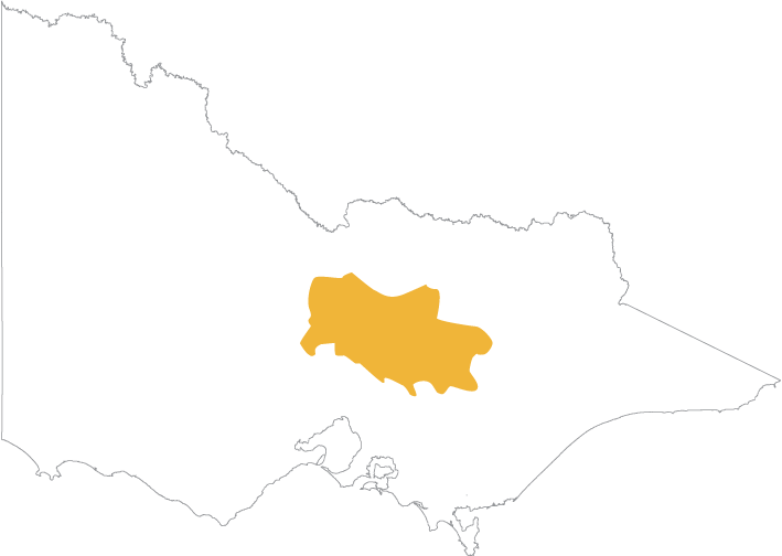
Download a map showing the boundaries for Taungurung Land and Waters Council Aboriginal Corporation:
Taungurung Land and Waters Council Aboriginal Corporation Map 8 FEB 2019
(opens in a new window)
You can also view an online map(opens in a new window) showing all Registered Aboriginal Party boundaries in Victoria. The map works best in Chrome.
Once the online map is displayed:
- Click the Layers icon on the toolbar above the map.
- Select the Appointed RAPs checkbox.
Contact
Post: 37 High Street, Broadford Victoria 3658
Phone: 03 5784 1433
Website: taungurung.com.au(opens in a new window)
CEO
Matt Burns
Email: mburns@tlawc.com.au
RAP Director
Katherine Thomas, Director – RAP Unit
46 Aitken St, Alexandra Victoria 3714
Email: careforculture@tlawc.com.au
Council decisions regarding Taungurung Land and Waters Council
JUL 2009 Taungurung RAP appointment
(opens in a new window)
AUG 2009 Taungurung RAP area extended
(opens in a new window)
JUN 2013 Taungurung boundary variation
(opens in a new window)
APR 2014 decision about Taungurung RAP boundary
(opens in a new window)
MAR 2018 Taungurung boundary variation
(opens in a new window)
FEB 2019 Taungurung boundary variation
(opens in a new window)
Updated